
Operating a flood warning system in West Africa
Floods are a growing concern in West Africa and they are projected to increase due to climate change. There is a great need for reliable access to operational flood forecasts and alerts, produced by a robust Information and Communication Technology (ICT) system, adapted to regional conditions and operated by West African institutions.
The FANFAR project, funded by the European Commission (EC) aims at building such a system. In this context, isardSAT's satellite-based water level products of the Niger River basin floodplain are sequentially assimilated into a hydrological model from the Swedish Meteorological and Hydrological Institute (SMHI) to generate river discharge return periods. These results are then used in SMHI’s flood forecasting and early-warning alert system in West Africa.
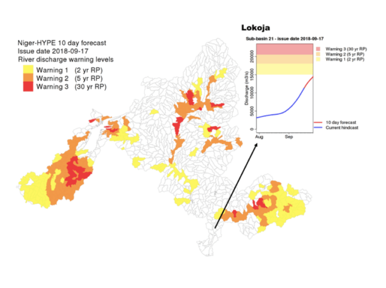
The Hydrology TEP operates this flood warning system, by running isardSAT's satellite-based, global water level service. This water level service is well-suited to complement in-situ sensor networks. It can also be used as a proxy of streamflow, for model calibration and validation as well as for hydrologic data assimilation.
FANFAR is providing reliable and timely access to flood forecasts and alerts through a range of distribution channels to ensure that the information reaches its target audience. These distribution channels include web visualisations, SMS, e-mail and Application Programming interfaces (API).